Computational methods for archaeological fieldwork
By utilising technical install guides and step-by-step tutorials to the relevant software, the students were, over several teaching sessions, introduced to three digital methods commonly used in archaeological fieldwork (GIS, RTI and Photogrammetry). In an attempt to balance frustration with positives experiences, an emphasis was put on small and simple tasks that yielded outputs that were more tangible and easy to work with for the students while they were still learning the new methods.
Motivation
Knowledge of computational methods is a basic requirement for professional archaeologists, but it is missing from the curriculum in the BA Classical Archaeology. The teacher aimed to make strategic and small additions and changes to the existing curriculum to give students more exposure to computational methods and resources, and some practical experience with a few methods that will become relevant to their fieldwork. Experience with these computational methods should also enhance their employability. Such strategic additions were made to three courses (studium generale, topic in classical archaeology, and archaeological fieldwork). This teaching case concerns the latter.

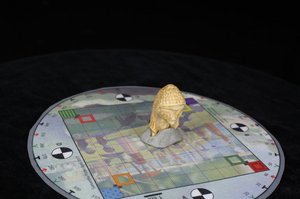
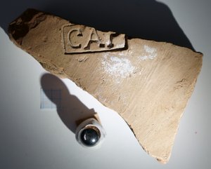
To help demonstrate the relevance of computational methods to archaeological fieldwor, it was decided to focus on easy-to-learn/hard-to-master computational techniques that can be applied in the field during excavations, and that provide direct useful outputs/products. This concerns GIS (geographical information systems), RTI (reflectance transformation imaging), and photogrammetry. Data and objects was provided for the students, including a stamped Roman brick and the head of a small statuette.
Use of technology
- Geographical information systems (GIS): Software QGIS
- Reflectance Transformation Imaging (RTI): Software RTIbuilder and RTIviewer
- Photogrammetry software: Metashape
These are all computational methods that can be applied directly in archaeological fieldwork, and the basics of the approach can be taught in just a few hours with the student creating a tangible output, such as a map, an RTI-file or a 3D-model.
See screenshots of the photogrammetry software here. You can find the other tutorials and handouts under "Links and materials".
Outcome
The majority of the students agreed that they had gained new computational skills that can have relevance in different professional environments. Some students enjoyed the diversity that these classes brought to their curriculum. All the students are now aware of the range of computational tools that exist and have access to resources they can draw on when the tools become relevant.
Activities
Course of action for teaching a new digital method:
In advance of the first lesson on a given digital method, the students are told to install the software on their computers, so that the time in class can focus on teaching the new tool, instead of solving technical issues.
- The students listen to a lecture giving an overview of relevant computational methods, their strengths and some challenges (in class)
- The students are then introduced to a step-by-step tutorial on how to fulfil a task with a specific software (in class)
- The students begin completing the task with the specific software following the tutorial and with the opportunity to ask questions to the teacher (in class)
- The students complete the tutorial after the class at home and perform additional tasks
- The results are emailed to the lecturer before the next class.
- The students receive feedback in the next lesson
The series of activities is repeated for each tool/method (geographical information systems (GIS), reflectance transformation imaging (RTI) and photogrammetry).
Example: RTI class
For this class we used and older and free-of-charge software which is still the industry standard but does not work on all machines. For this reason we gave the students detailed installation instructions (see the instructions here) two weeks in advance, which were reiterated in the lecture slides each week and also emailed via Blackboard (Attention: Blackboard was AUs former LMS). The step-by-step installation instructions proved crucial to enable some of the students to successfully install the necessary software and take part in the class, and it also avoided wasting time during the class on software installation issues.
The class starts with a very short introduction of what RTI is (see the slides here) and followed by a practical tutorial that each student does independently. Lecturers then help individual students who are stuck. A step-by-step tutorial was prepared (see the tutorial here) that includes all information the students need to do the exercise completely independently. Crucially, this includes a lot of screenshots so the students can make sure that they are on the right track. This way of teaching allows students to work at their own pace, and allows those working slowest to independently complete it at home.
Ressources and support
- The students are given lecture slides and step-by-step tutorials including a detailed guide on how to install the different software they have to use
- Students have access to the teacher for questions and technical support in relation to problems with the software.
- Furthermore, students are given a list of additional tutorials, test datasets and literature.
- Students get feedback on submitted tasks in class
Example RTI:
For those students who want to takes things further, we included a slide with literature and other tutorials (see slide 8 in the linked materials), another home exercise (slide 9) and a slide with additional resources (slide 10).
Challenges and advice
- Not all students perform and submit non-mandatory out-of-class tasks, limiting the benefits of the asynchronous parts of the teaching.
- Few students had computational experience, so a lot of basic things needed to be introduced.
- A piece of advice is to use step-by-step handout tutorials. They allow the students to either follow the teacher’s demonstration or work at their own pace.
- Another advice is to have a document that describes how to overcome basic technical issues, from which you can just copy-paste when an issue comes up. Make sure to remind the students what software that needs to be installed and what requirements that exists, weeks ahead of the class in question and repeat it for every new piece of software.
Tom Brughmans on his teaching case:
Basic information:
Teacher: Tom Brughmans
Faculty: Arts, Aarhus University
Discipline: Classical Archaeology
Course: Fieldwork
Level of study: BA
Teaching method: Small class teaching
Number of students: 10
Duration: Short series of activities
Academic objective
The academic objective of this course is to obtain an overview of relevant computational methods, including their strengths and challenges. Furthermore, for the students to gain basic practical competencies in geographical information systems (GIS), reflectance transformation imaging (RTI) and photogrammetry.
